Climate Change and Fluctuating
Water Levels on the Great Lakes
The predictable cycles that shaped shoreline communities for generations are giving way to volatile swings that catch everyone off guard
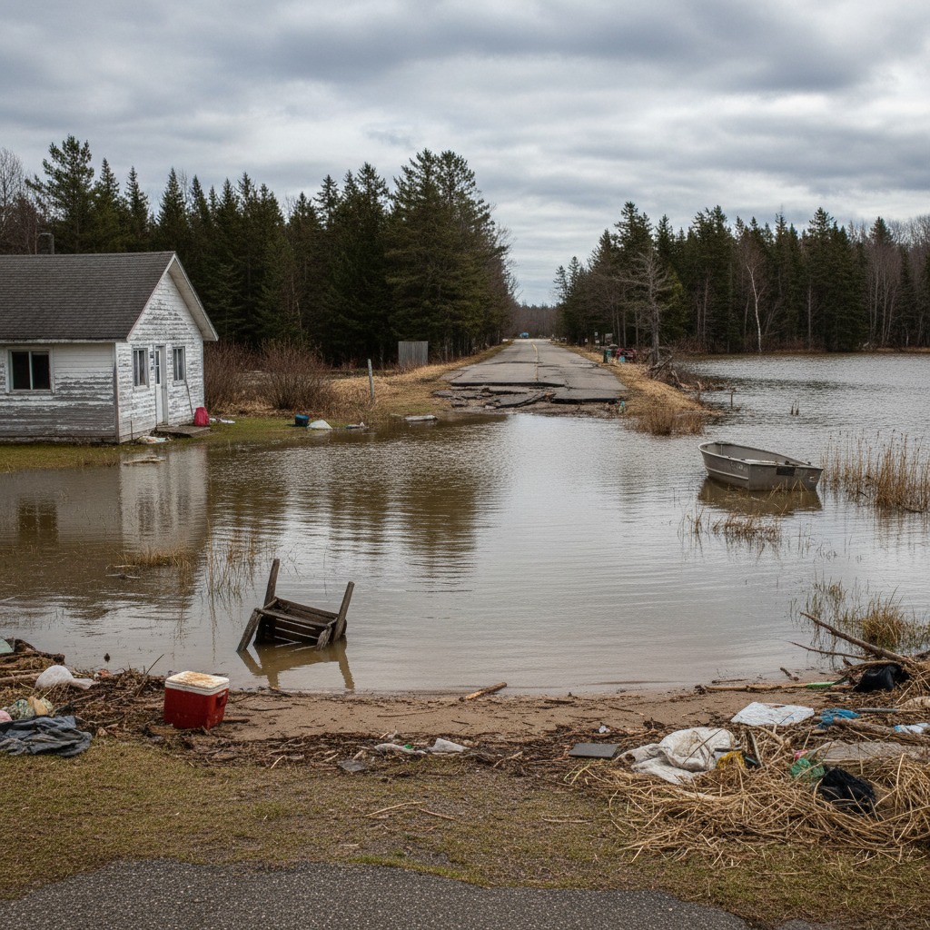
In 2013, water levels on Lake Michigan-Huron dropped to their lowest recorded point. Docks sat on dry land. Boat launches were unusable. Harbours needed dredging to remain navigable. Just seven years later, in 2020, the same lake system hit its highest recorded level. Shoreline properties that had gained beach during the low-water years were now flooding. Retaining walls were overwhelmed. Entire sections of road were washed out.
This swing from record low to record high in less than a decade illustrates the volatility that climate change is bringing to the Great Lakes water level regime. While the lakes have always experienced multi-year cycles of high and low water, the amplitude and speed of recent fluctuations are outside the historical norm. For the millions of people who live, work, and recreate along the Great Lakes shoreline, this new reality demands a fundamental rethinking of how we build, plan, and manage the water's edge.
Understanding the Cycle
Great Lakes water levels are determined by the balance between water inputs, primarily precipitation and runoff from the surrounding watershed, and water outputs, primarily evaporation and outflow through connecting channels. This balance is influenced by temperature, precipitation patterns, wind, and ice cover, all of which are affected by climate change.
Historically, the Great Lakes have experienced roughly 30-year cycles of high and low water, with fluctuations of about one to two metres between the extremes. These cycles are driven by regional climate patterns that affect precipitation and evaporation rates over multi-year periods. Communities along the shore adapted to these cycles, building during low-water periods and dealing with flooding during high-water periods, but the pace was gradual enough that most structures and infrastructure could cope.
What climate change is doing is disrupting both the timing and the magnitude of these cycles. The warming climate is increasing evaporation rates, which in some periods drives water levels down. But it is also intensifying the hydrological cycle, producing heavier precipitation events that can rapidly boost water levels. The net effect is not a consistent trend in one direction, but rather greater volatility, with more extreme highs and lows occurring in shorter time frames.
The Evidence
Scientific research on Great Lakes water levels and climate change has produced several consistent findings. Warming temperatures are extending the ice-free season on the lakes, which increases the period during which evaporation can occur. Less ice cover in winter also means more exposure to wave action during storms, accelerating shoreline erosion. At the same time, more moisture in the atmosphere is producing heavier individual precipitation events, even as the total number of precipitation days may not change significantly.
The rapid swing from record lows to record highs on Lake Michigan-Huron between 2013 and 2020 was driven largely by a shift from a dry precipitation regime to an exceptionally wet one. The speed of this transition surprised researchers and underscored the difficulty of predicting water levels even a few years into the future. Climate models project a wide range of possible future water level scenarios, from continued volatility to a gradual long-term decline, depending on which climate trajectory the world follows.
What is less uncertain is that the future will not look like the past. The historical water level record, which extends back to the 1860s for most lakes, may no longer be a reliable guide to what property owners, municipalities, and infrastructure planners should expect.
Impacts on Communities
The practical impacts of volatile water levels are felt differently depending on whether levels are high or low, but both extremes create problems. During high-water periods, waterfront properties flood. Basements fill. Septic systems fail. Retaining walls are overtopped. Roads and utilities close to the shore are damaged or destroyed. Beaches disappear, and public access points become hazardous. The costs to individual property owners and to municipalities can run into the millions.
During low-water periods, different problems emerge. Boat launches and marinas become inaccessible. Navigation channels need dredging. Water intakes for municipal supply can be affected. Wetlands dry out, exposing lakebed that is colonized by invasive plants. Recreational use of the waterfront declines, affecting tourism-dependent economies.
The whiplash between extremes is perhaps the most challenging aspect. A property owner who invests heavily in flood protection during a high-water period may find that investment stranded when levels drop. A marina operator who dredges to accommodate low water may find the dredged area flooding within a few years. Planning for one extreme leaves communities vulnerable to the other.
Adapting to Uncertainty
The key challenge for Great Lakes communities is learning to plan for uncertainty rather than for a specific water level. This means designing infrastructure and development to function across a wider range of water levels than has historically been considered. Setback requirements for new construction should account for worst-case high-water scenarios. Flood-proofing standards should be updated to reflect the new reality of more frequent and more extreme high-water events.
Natural shoreline approaches, including vegetated buffers, restored wetlands, and naturalized slopes, are generally more adaptable to water level fluctuations than hard engineered structures. They can absorb and recover from both high and low water events in ways that concrete and steel cannot. Expanding the use of these approaches along the Great Lakes is one of the most effective adaptation strategies available.
Improved monitoring and forecasting can help communities prepare for extreme water level events. The Canadian Hydrographic Service and the International Joint Commission provide water level data and seasonal forecasts for the Great Lakes, but investment in better modelling and longer-range forecasting would give communities more time to prepare for both high and low water conditions.
Perhaps most importantly, communities need to accept that the water's edge is a dynamic, moving boundary, not a fixed line on a survey plan. Building as if the shoreline will remain where it is today is a gamble that climate change is making increasingly risky. The communities that adapt most successfully will be those that respect the power of the water and plan accordingly.
By Maren Falk, Environment Editor