What Happens to Fish Habitat
When Shorelines Get Developed
The connection between what we build on shore and what lives in the water is direct, measurable, and often overlooked
When a property owner clears the vegetation along their shoreline, installs a retaining wall, and builds a dock, the changes are obvious on land. What is less visible is what happens beneath the water's surface. The insects that once dropped from overhanging branches into the water disappear. The shade that kept nearshore water cool vanishes, raising temperatures beyond the tolerance of some fish species. The submerged root systems that provided shelter for juvenile fish are ripped out. The gravel beds where bass and walleye spawned get buried under silt washed from the newly exposed soil.
Shoreline development and fish habitat are intimately connected. Every modification to the land at the water's edge has consequences in the aquatic environment. Understanding those consequences is essential for anyone who cares about fishing, water quality, or the long-term health of Ontario lakes and rivers.
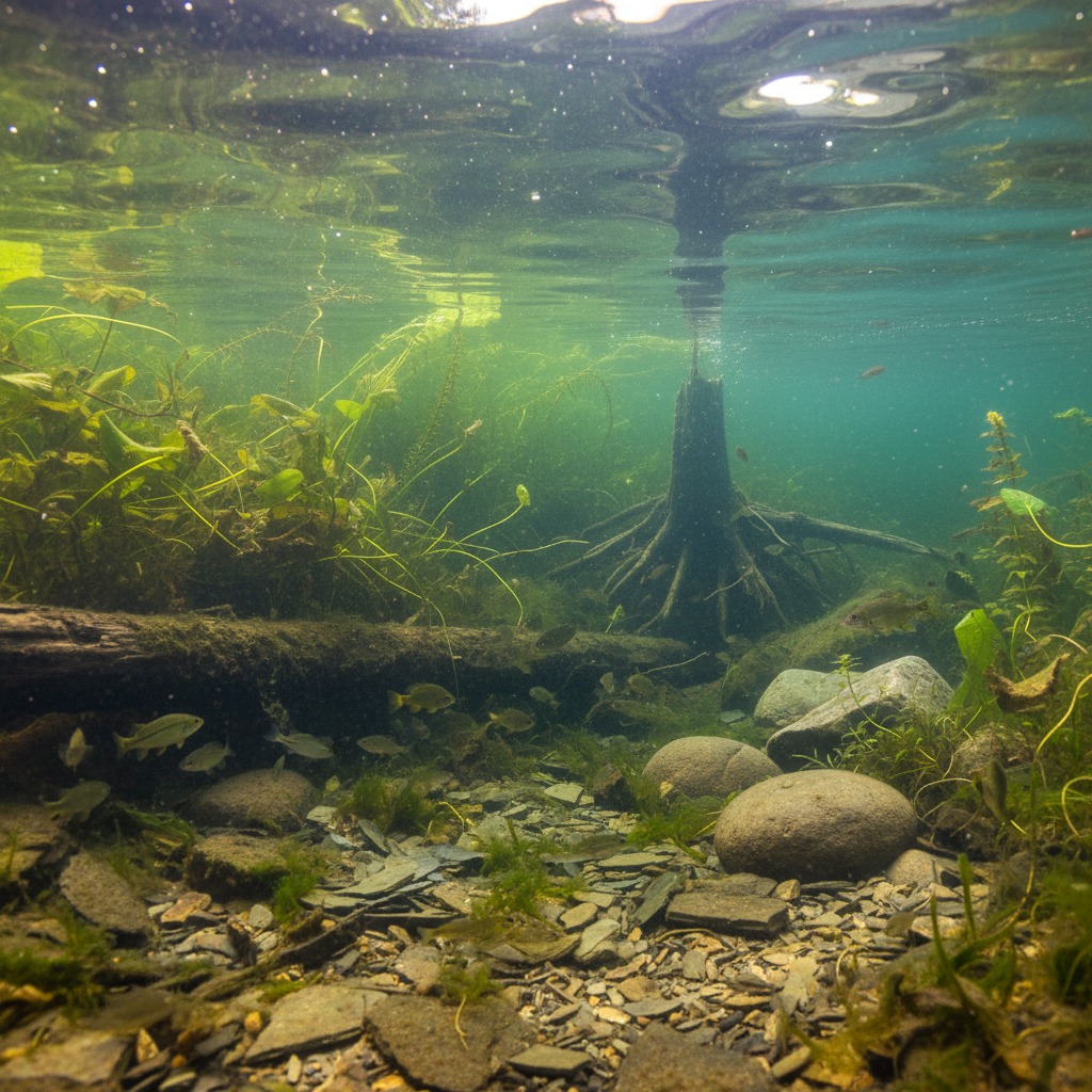
What Fish Need
Fish habitat is not simply water. It is a complex combination of physical structure, water quality, temperature, food sources, and seasonal conditions that together support the various life stages of different fish species. A largemouth bass, for example, needs warm, sheltered shallows with vegetation for spawning in spring, submerged structure such as logs and rock for cover, and a food supply of insects, crayfish, and smaller fish throughout the growing season. A brook trout needs cold, well-oxygenated water, clean gravel for spawning, overhead cover from riparian vegetation, and a food web based on aquatic insects that in turn depend on leaf litter from streamside trees.
The shoreline zone, typically defined as the area from the high-water mark to a depth of about two metres, is disproportionately important for fish. This is where most spawning occurs, where juvenile fish find the shelter and food they need to survive their most vulnerable life stages, and where the terrestrial and aquatic ecosystems interact most intensely. The quality of this nearshore habitat has a direct and measurable effect on fish populations.
How Development Changes Things
The most common shoreline modifications, those that seem harmless or even attractive to property owners, are often the most damaging to fish habitat. Clearing native vegetation from the shoreline removes the root systems that hold soil in place, the overhanging branches that provide shade and insect input, and the leaf litter that feeds the base of the aquatic food web. Studies on Ontario lakes have found that developed shorelines with cleared vegetation support significantly fewer fish species and lower fish biomass than natural or naturalized shorelines.
Retaining walls and seawalls replace the complex, irregular natural shoreline with a uniform vertical surface that offers little or no habitat for fish, invertebrates, or aquatic plants. Natural shorelines have gradual transitions from land to water, with varying depths, substrates, and vegetation that create diverse microhabitats. A concrete or steel wall eliminates all of that complexity and often creates conditions where wave energy is reflected rather than absorbed, scouring the lakebed in front of the wall and further degrading habitat.
Docks and boat lifts have more nuanced effects. They can provide some structure and shade that fish may use, but the boat traffic they support can disturb spawning areas, resuspend sediment, and create wave action that erodes adjacent shorelines. In areas of concentrated dock development, the cumulative impacts on nearshore habitat can be significant.
Impervious surfaces on waterfront properties, including roofs, driveways, and patios, increase stormwater runoff that carries sediment, nutrients, and pollutants directly into the water. This runoff can bury spawning substrate, degrade water quality, and fuel algae growth that further alters habitat conditions.
The Cumulative Effect
Individual shoreline modifications might have modest impacts on their own. The problem is cumulative. When one property on a lake clears its shoreline, the effect on the overall fish population is negligible. When half the properties on the lake do the same thing, the impacts become substantial. Research on lakes in Ontario and elsewhere has consistently found that fish diversity and abundance decline as the proportion of developed shoreline increases. Lakes with more than 50 percent developed shoreline tend to have significantly impaired fish communities compared to lakes with predominantly natural shorelines.
This cumulative degradation is especially concerning because it happens incrementally, one property at a time, and is difficult to reverse once it has occurred. No single property owner feels responsible for the decline, and no single restoration project can undo the combined effects of decades of development across an entire lake.
Legal Protections
Fish habitat in Canada is protected under the federal Fisheries Act, which prohibits the harmful alteration, disruption, or destruction of fish habitat without authorization. This means that any shoreline modification that has the potential to affect fish habitat, including dock construction, retaining wall installation, shoreline clearing, and dredging, may require a review and potentially an authorization from Fisheries and Oceans Canada.
In practice, enforcement of the Fisheries Act as it relates to shoreline development is inconsistent. Many small-scale modifications proceed without review. Conservation authorities in Ontario play an important role in screening development proposals near water and flagging those that may affect fish habitat, but their capacity to review every project is limited. The result is that a significant amount of incremental habitat loss occurs below the regulatory radar.
Ontario's Provincial Policy Statement also requires that development avoid negative impacts on fish habitat and that any unavoidable impacts be mitigated or offset. Municipalities are expected to implement these policies through their official plans and zoning bylaws, but the degree of compliance varies widely.
What Property Owners Can Do
The good news is that protecting and restoring fish habitat along developed shorelines does not require abandoning the property. Simple measures can make a significant difference. Maintaining a buffer of native vegetation along the shoreline, even a strip as narrow as three to five metres, provides shade, insect input, root structure, and erosion control. Leaving fallen trees and woody debris in the water rather than removing them provides important fish cover. Replacing hard retaining walls with naturalized slopes planted with native species restores habitat function while still protecting the property from erosion.
When dock construction is necessary, designing docks that minimize their footprint, allow light penetration, and avoid sensitive spawning areas can reduce impacts. Using floating docks rather than permanent cribs avoids filling valuable nearshore habitat. Keeping boat traffic speeds low in shallow areas reduces shoreline erosion and sediment disturbance.
Some Ontario lake associations and conservation authorities offer shoreline naturalization programs that provide advice, native plants, and sometimes financial incentives to property owners who restore their shorelines. These programs recognize that the cumulative effect of many small improvements across a lake can be just as powerful as the cumulative damage that created the problem.
The Bigger Picture
Fish habitat is not a niche concern for anglers. Healthy fish populations are indicators of healthy water systems, and healthy water systems are the foundation of everything that makes waterfront living and recreation valuable. The same nearshore habitat that supports fish also filters water, stabilizes shorelines, and supports the broader ecosystem that draws people to the water in the first place.
Protecting that habitat is not about preventing development. It is about developing thoughtfully, with an understanding that the water's edge is a shared resource and that what happens on land has direct consequences in the water below.
By Maren Falk, Environment Editor