How Shoreline Erosion Is Reshaping
the Great Lakes
High water, fierce storms, and decades of development are eating away at the coastline faster than many communities can respond
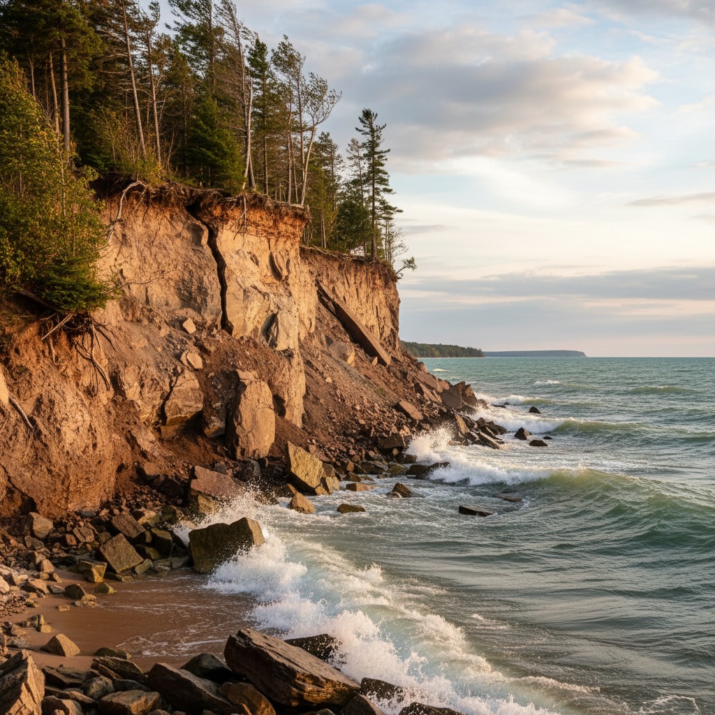
Stand on a bluff overlooking Lake Huron near Grand Bend, and you can see where the land used to be. A row of cottages that once sat twenty metres from the edge now teeters on the brink. In some places, the cliff face has retreated more than a metre in a single season. This is shoreline erosion on the Great Lakes, and it is not a new problem. But it is getting worse.
Erosion has always been part of the natural cycle of the Great Lakes. Wind, waves, ice, and rain have shaped these coastlines for thousands of years. What has changed in recent decades is the pace. Higher water levels, more intense storms, and the cumulative effects of shoreline development have combined to accelerate erosion along stretches of coast that communities thought were stable. Properties that seemed safe when they were purchased are now at risk, and the costs of protection are climbing fast.
The Scale of the Problem
The Great Lakes contain roughly 20 percent of the world's surface freshwater, and their combined shoreline stretches over 17,000 kilometres. Every section of that shoreline is subject to erosion, but the severity varies dramatically depending on geology, exposure, and human activity. Sandy bluffs along Lake Erie and Lake Huron are particularly vulnerable. The clay bluffs that line much of the north shore of Lake Ontario are also eroding at rates that have alarmed both property owners and municipalities.
Research from the Geological Survey of Canada and various conservation authorities has documented erosion rates averaging between 0.3 and 1.5 metres per year along some of the most affected stretches. In extreme years, when water levels peak and storms arrive at just the right angle, individual properties have lost several metres of land in a matter of weeks. The 2017 and 2019 high-water events on Lake Ontario and Lake Erie brought this reality into sharp focus, causing tens of millions of dollars in property damage and prompting emergency responses in dozens of communities.
What Drives Erosion
Understanding Great Lakes erosion requires looking at several forces working together. The most immediate driver is wave action. When water levels are high, waves reach higher up the shoreline and strike with more energy. Bluffs that are normally above the reach of waves become exposed. The base of the bluff gets undercut, and gravity does the rest, bringing down chunks of soil and rock in what geologists call mass wasting events.
Water levels on the Great Lakes follow long cycles. Lake Michigan-Huron hit record highs in 2020 after years of above-average precipitation. Lake Ontario saw extreme highs in 2017 and 2019, driven partly by inflows from Lake Erie and partly by heavy rainfall events. These high-water periods dramatically accelerate erosion along vulnerable shorelines because the wave energy reaches areas that were previously protected.
Ice cover also plays a role. In a typical winter, ice along the shoreline acts as a natural buffer, protecting the coast from wave action during the stormiest months. But ice cover on the Great Lakes has been declining steadily over the past several decades. With less ice, the shoreline is exposed to winter storms that pound it with cold, powerful waves during the season when bluff soils are saturated and most vulnerable to collapse.
Human activity compounds these natural forces. Shoreline hardening, where property owners install seawalls, rock armour, or concrete barriers, can protect one property while redirecting wave energy to neighbouring properties. Stormwater runoff from developed areas saturates bluffs from above, weakening the soil. Removal of natural vegetation exposes soil to rain and wind. The cumulative effect of decades of development along the coast has made many stretches of shoreline less resilient than they once were.
Communities on the Edge
The human cost of shoreline erosion is measured in lost land, threatened homes, and declining property values. Along the Lake Erie shore in Norfolk County, homeowners have watched their backyards shrink year after year. Some have invested tens of thousands of dollars in rock armour and gabion baskets, only to see the erosion continue around the edges of their protection. Others have been forced to demolish structures that were dangerously close to the edge.
Municipal governments face their own challenges. Roads, water mains, and sewer lines that were built decades ago with comfortable setbacks from the shore are now at risk. In Chatham-Kent, sections of Lakeshore Road along Lake Erie have required emergency repairs after erosion undercut the road base. The municipality has spent millions on temporary measures while studying long-term options that could cost tens of millions more.
Conservation authorities, which regulate development within hazard lands in Ontario, have been updating their erosion hazard mapping, but the process is slow and expensive. Many of the erosion rate estimates that inform setback requirements are based on historical averages that may not reflect the accelerating trends of recent decades. This creates a gap between the regulations on paper and the reality on the ground.
The Options for Property Owners
Property owners facing erosion have several options, none of them cheap. Hard protection measures such as steel sheet piling, concrete seawalls, and engineered rock armour can cost anywhere from $500 to $2,000 per linear metre, depending on the severity of the erosion and the site conditions. These measures can be effective at protecting individual properties, but they require permits, engineering assessments, and in many cases approval from multiple agencies including the local conservation authority and the federal Department of Fisheries and Oceans.
Softer approaches, sometimes called natural shoreline protection or bioengineering, use vegetation, grading, and natural materials to stabilize slopes and absorb wave energy. These methods are generally less expensive than hard armouring and are often preferred by conservation authorities because they maintain habitat and do not redirect wave energy to neighbouring properties. However, they may not be sufficient for properties facing severe erosion on exposed stretches of coast.
A growing number of experts argue that managed retreat, accepting that some areas will be lost to erosion and relocating infrastructure and homes away from the edge, is the most realistic long-term response in the most severely affected areas. This approach is politically difficult because it means acknowledging that certain properties are not worth protecting at public expense, and it raises difficult questions about compensation and responsibility.
Looking Ahead
Climate projections for the Great Lakes region suggest that the factors driving erosion are likely to intensify in the coming decades. More extreme precipitation events will keep water levels volatile. Warmer winters will continue to reduce ice cover. More intense storms will generate larger waves. All of this points to continued and possibly accelerating erosion along vulnerable stretches of coast.
The challenge for communities, property owners, and regulators is to move beyond reactive responses and develop long-term strategies that account for the new reality. That means updating erosion hazard mapping with better data. It means rethinking setback requirements for new construction. It means investing in natural shoreline protection where possible and accepting managed retreat where necessary. And it means honest conversations about who pays for it all.
The Great Lakes shoreline has always been dynamic. What is different now is the speed of change and the amount of human infrastructure in its path. How Ontario responds to this challenge will shape the future of waterfront communities for generations to come.
By Maren Falk, Environment Editor