Spring Flooding and the River Towns
That Bear the Brunt
When the snow melts and the rain comes, some Ontario communities know exactly what is about to happen, and they know there is not much they can do about it
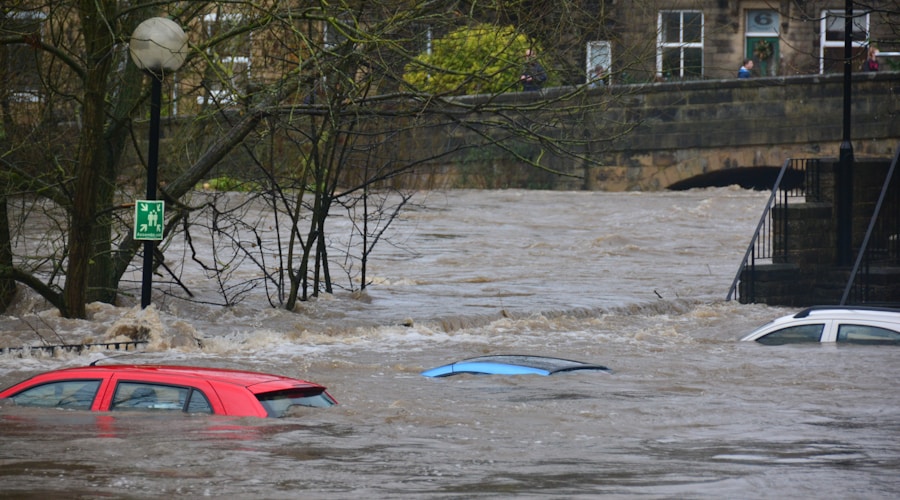
Every spring in Bracebridge, residents along the Muskoka River watch the water rise and wonder if this will be the year it reaches their front door. In Minden Hills, shop owners along the Gull River know that a late-season rainstorm on top of a heavy snowpack can turn their main street into a canal. In communities along the Grand, the Thames, the Rideau, and dozens of other Ontario rivers, the spring thaw is not just a welcome sign of warmer weather. It is the beginning of flood season.
Spring flooding is a natural process that has shaped Ontario river valleys for thousands of years. The problem is that people have built towns, roads, and infrastructure in the paths of these floods, and the changing climate is making the floods bigger, more frequent, and less predictable than the historical experience that guided past development decisions.
Why River Towns Flood
The basic mechanics of spring flooding are straightforward. Snow accumulates over the winter. When temperatures rise in spring, the snowpack melts, releasing water into streams and rivers. If the ground is still frozen or saturated, the meltwater cannot infiltrate into the soil and runs off directly into the waterway. If rain falls on top of the melting snow, the combined volume of water can exceed the capacity of the river channel, and the excess spills onto the adjacent floodplain.
Ontario river towns tend to be located where they are for good historical reasons. Rivers provided transportation, power for mills, and water for agriculture and industry. The flat, fertile floodplains adjacent to rivers were attractive for settlement. These same characteristics make them vulnerable to flooding. The flat land that was easy to build on is flat precisely because it is a floodplain, shaped by centuries of periodic inundation.
The severity of spring flooding in any given year depends on several factors: the volume of snow that accumulated over the winter, the speed of the melt, the amount of rain that falls during the melt period, the state of the ground, whether it is frozen or thawed, saturated or dry, and the condition of ice on the river. Ice jams, where broken river ice piles up at constrictions such as bridges, bends, or narrow channels, can cause sudden and severe flooding by damming the river and forcing water out of its banks.
Getting Worse
Multiple factors are making spring flooding more problematic across Ontario. Climate change is increasing the frequency of extreme precipitation events, which means more intense rainstorms during the spring melt period. Warmer winters are producing more mid-winter thaw events, followed by re-freezing, which can create thick ice layers that block drainage and contribute to ice jam formation. The timing of the spring melt is becoming less predictable, making it harder for communities to prepare.
Land use change is compounding the climate effect. As forests and wetlands are converted to farmland, suburbs, and commercial development, the landscape loses its natural capacity to absorb and store water. Wetlands that once held back floodwater have been drained. Forests that intercepted rain and snow have been cleared. Impervious surfaces, including roads, roofs, and parking lots, increase the volume and speed of runoff reaching rivers during storm events.
Aging infrastructure adds another layer of vulnerability. Many Ontario river towns have stormwater systems, bridges, and culverts that were designed and built decades ago, based on flow estimates that no longer reflect current conditions. These structures are undersized for the volumes of water they now need to handle, and replacing them is expensive.
The Human Cost
For families living in flood-prone areas, the annual threat of spring flooding takes a toll that goes beyond property damage. The stress of watching water levels rise, the exhaustion of sandbagging through the night, the heartbreak of pumping a flooded basement, and the frustration of dealing with insurance companies and government assistance programs wear on people year after year. Some residents have been flooded multiple times and face the difficult decision of whether to stay or leave a home and community they love.
The financial costs are significant. Flood damage to homes can range from a few thousand dollars for a minor basement seepage to tens of thousands for a major event that damages foundations, electrical systems, and finished spaces. Many waterfront and floodplain homeowners have difficulty obtaining affordable flood insurance, and government disaster assistance programs are often slow and do not cover all losses.
Municipalities face their own costs. Emergency response during flood events requires personnel, equipment, and coordination that strain local resources. Damage to roads, bridges, water systems, and other infrastructure requires repair or replacement. The disruption to local businesses and tourism during and after flood events has economic ripple effects that can persist long after the water recedes.
What Communities Are Doing
Ontario river towns are responding to the increasing flood risk with a combination of structural measures, land use planning, emergency preparedness, and, in some cases, difficult conversations about managed retreat from the most vulnerable areas.
Structural flood mitigation measures include berms, floodwalls, channel improvements, and flood control dams that hold back water during peak flows. These measures can be effective but are expensive to build and maintain, and they can create a false sense of security that encourages more development in protected areas. If a flood exceeds the design capacity of the protection, the consequences can be worse than if no protection existed at all.
Updated floodplain mapping is critical for informed land use planning. Many Ontario communities rely on floodplain maps that are decades old and do not reflect current conditions, including changes in land use, climate, and the river channel itself. Conservation authorities are gradually updating these maps using modern modelling and remote sensing technology, but the process is expensive and progress is slow.
Some communities are exploring buyout programs that acquire the most flood-prone properties and return the land to a natural state. This approach removes people and structures from harm's way permanently and restores the floodplain's natural function as a water storage and conveyance area. Buyout programs are expensive upfront but eliminate the recurring costs of emergency response and damage repair. The challenge is that they require willing sellers and sufficient funding, and the emotional attachment that people have to their homes makes voluntary buyouts difficult in practice.
Living with the River
The fundamental challenge for Ontario river towns is accepting that flooding is not an abnormal event to be eliminated but a natural process to be managed. Rivers flood. They have always flooded. The floodplain belongs to the river, and the water will return to it periodically regardless of what we build there.
The communities that will fare best in the decades ahead are those that plan with this reality in mind. That means keeping new development out of the most vulnerable areas, investing in natural infrastructure such as wetlands and riparian buffers that slow and store floodwater, maintaining and upgrading the built infrastructure that protects existing development, and preparing residents for the events that will inevitably come.
It also means supporting the people who are flooded when prevention fails. Better insurance options, faster disaster assistance, and mental health support for flood-affected families are all part of a comprehensive response to a problem that is not going away.
By Maren Falk, Environment Editor