Communities Along the Rideau Canal
Living alongside a UNESCO World Heritage Site that doubles as a backyard, a commute route, and a way of life
The Rideau Canal runs 202 kilometres from Kingston to Ottawa, passing through 47 locks, a chain of lakes and rivers, and some of the most quietly appealing communities in eastern Ontario. Built between 1826 and 1832 under the direction of Lieutenant Colonel John By, the canal was a military project intended to provide a secure supply route between Montreal and the Great Lakes in the event of American attack. That attack never came, and the canal found its purpose instead as a commercial waterway, then a recreation corridor, and finally, in 2007, a UNESCO World Heritage Site.
The communities along the Rideau are shaped by this history in ways visible on every main street and at every lock station. The stone buildings, the heritage architecture, the lock mechanisms that still operate by hand, and the pace of boat traffic all reflect a waterway that has moved through different eras without losing its essential character. For the people who live in these towns, the canal is not a museum piece. It is the backdrop to daily life, the reason tourists arrive in summer, and the defining feature of their communities.
Kingston Mills to Smiths Falls
The canal begins at Kingston Mills, just north of Kingston, where the first set of locks lifts boats from the Cataraqui River toward the interior. The landscape here is Canadian Shield, with rocky outcrops, mixed forest, and the narrow passages that made this section of the canal the most difficult to construct. The communities are small. Seeleys Bay, a village on the canal route, has a general store, a marina, and a population that swells dramatically in summer when cottagers and boaters arrive.
Jones Falls, home to one of the most impressive stone arch dams in North America, is a lock station rather than a town, but it represents the engineering ambition that characterizes the entire system. The dam, built by labourers under conditions that killed many of them, impounds the water that feeds the upper reaches of the canal.
Smiths Falls is the largest town on the canal between Kingston and Ottawa, and it sits at the midpoint of the system. The Rideau Canal Museum, housed in a former mill building, tells the story of the canal's construction and its role in the region's development. The town has a downtown waterfront that provides public access to the canal and serves as a stopping point for boaters transiting the system. Smiths Falls has experienced the economic challenges common to many small Ontario towns, including the closure of its Hershey chocolate factory, but the canal remains a constant, drawing visitors and providing an identity that anchors the community.

Merrickville: The Jewel of the Rideau
Merrickville, about 80 kilometres south of Ottawa, has earned its reputation as the prettiest village on the canal through a combination of heritage preservation, cultural investment, and natural setting. The village centre, built largely of local stone in the nineteenth century, has been maintained and repurposed rather than demolished and replaced. Galleries, studios, restaurants, and specialty shops occupy buildings that have stood for 150 years or more, and the streetscape has a coherence and authenticity that many communities have lost.
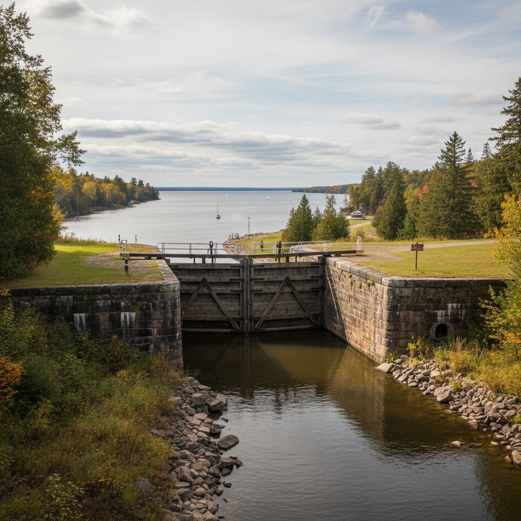
The canal and its locks are the centrepiece of the village. Parks Canada staff operate the locks by hand, just as they have been operated since the canal opened, and watching a boat pass through the chamber is a small ritual that draws visitors throughout the boating season. The blockhouse, a stone defensive structure dating to the canal's military origins, stands beside the locks as a tangible connection to the waterway's original purpose.
Merrickville benefits from proximity to Ottawa while maintaining a distinctly rural and small-town character. The drive to the capital takes about an hour, putting the village within commuting range for some workers. This accessibility has driven up property values, and the tension between preserving the village's character and accommodating growth is a persistent topic. Similar pressures affect many waterfront small towns across the province, but in Merrickville the stakes feel particularly high because what could be lost is so clearly worth preserving.
Westport and the Upper Rideau
Westport sits at the western end of Upper Rideau Lake, one of the natural lakes incorporated into the canal system. The village has a year-round population of about 600, a number that multiplies several times over in summer. The waterfront is the centre of village life, with a public beach, a marina, restaurants overlooking the lake, and a network of trails that connect the shoreline to the surrounding countryside.
Upper Rideau Lake and its neighbouring lakes offer some of the best paddling and fishing in the region. The water is clean, the shoreline is relatively undeveloped compared to more accessible lakes closer to major cities, and the pace of life is deliberately slow. Westport has a thriving arts community, and the combination of natural beauty, cultural activity, and small-scale community living makes it one of the most appealing places on the entire canal system.
Portland and Rideau Ferry
Portland, on Big Rideau Lake, and Rideau Ferry, where Upper and Lower Rideau lakes meet, are smaller communities that illustrate the quiet appeal of canal-system living. These are places where the water is the primary reason people are there, whether as year-round residents, seasonal cottagers, or passing boaters. The services are modest, the pace is unhurried, and the relationship with the waterway is direct and unmediated.
Big Rideau Lake is one of the larger lakes in the system and supports a healthy fishery, good swimming, and the kind of on-water recreation that brings people back year after year. The choice between cottage and town waterfront living plays out along these shores, with some residents preferring the self-sufficiency of a lakeside property and others gravitating toward the social connections available in the village centres.
Manotick and the Approach to Ottawa
As the canal approaches Ottawa, the character of the communities along it changes. Manotick, once a small mill village on the Rideau River, has become a suburb of Ottawa with a heritage village centre that preserves some of the original character. Watson's Mill, a stone gristmill built in 1860 and still operational, anchors the village's heritage identity. The Rideau River through Manotick is popular with paddlers, and the village's proximity to Ottawa makes it a convenient starting point for exploring the canal system.
The transition from rural canal community to urban suburb is gradual but unmistakable as you move north toward Ottawa. The canal enters the capital city and becomes the famous skating corridor that draws international attention every winter. But the character of the canal, its pace, its heritage, and its role as a connector of communities, is established long before it reaches the city. It is defined by the small towns, the lock stations, and the stretches of quiet water between them.

The UNESCO Effect
The 2007 designation of the Rideau Canal as a UNESCO World Heritage Site brought international recognition and raised the profile of the communities along its route. The designation acknowledges the canal as the best-preserved example of a slack-water canal in North America and recognizes its outstanding universal value as a work of engineering and human effort.
For the communities along the canal, the UNESCO designation has been a mixed blessing. It has increased tourism, raised awareness, and provided a framework for heritage conservation. It has also created expectations about preservation that can conflict with the practical needs of living communities. Buildings cannot be easily modified. Infrastructure improvements require careful heritage review. The balance between conservation and adaptation is delicate, and the communities that navigate it most successfully are those that view their heritage as an asset to be managed rather than a constraint to be endured.
A Living Corridor
The Rideau Canal communities share a common resource and a common identity, but each expresses it differently. From the Shield country near Kingston to the agricultural landscape around Smiths Falls to the bedroom communities near Ottawa, the canal connects places that are geographically and economically distinct. What they share is a waterway that has shaped their history and continues to shape their future.
For anyone interested in how water shapes community character, the Rideau Canal system is one of the richest examples in the country. The towns along its route are not frozen in time. They are living communities that share a remarkable piece of infrastructure, and the way each one has adapted to that shared resource tells a story about what it means to live alongside water that belongs to everyone.
By Janet Leigh Cawston, Heritage and Communities Reporter