What Gives River Towns Their Character
How moving water shapes communities in ways that still water never does
Ontario has hundreds of communities built beside water, but not all waterfront towns feel the same. Lake towns sprawl along open shorelines, oriented toward the horizon. Canal towns arrange themselves around locks and basins, their rhythms set by the pace of boat traffic. River towns are something different entirely. They are compressed, channelled, shaped by the same forces that carved the valleys they inhabit. The water beside them is not still. It moves, and that movement gives river communities a quality that is difficult to name but immediately recognizable when you feel it.
The distinction between a lake town and a river town runs deeper than geography. It shows up in the layout of streets, the placement of buildings, the types of industry that took root, and the relationship between residents and the water that runs past their homes. Understanding what makes river towns distinctive requires paying attention to both history and the physical landscape.
The Mill Town Foundation
Most Ontario river towns exist because of falling water. A river with a change in elevation provided power, and power attracted mills. Mills attracted workers, suppliers, and services. Towns grew around the mills, and the river that powered them became the central feature of the community. Almonte on the Mississippi River, Paris on the Grand River, Campbellford on the Trent, Fergus on the Grand: all of these communities trace their origins to water power, and the legacy of that origin is visible today in their architecture, their layout, and their identity.
The mill buildings themselves are often the most prominent structures in these towns. Built from local stone or heavy timber, they were designed to withstand the vibrations of machinery and the constant presence of water. Many have survived because they were too solid and too expensive to demolish. The conversion of former mill buildings into restaurants, galleries, condominiums, and cultural spaces has become one of the most successful models of waterfront revitalization in Ontario. In Almonte, the old mill district is the heart of the community. In Paris, the stone buildings along the Grand are the visual signature of the town. These structures anchor their communities to a specific place and a specific history in a way that newer architecture rarely achieves.
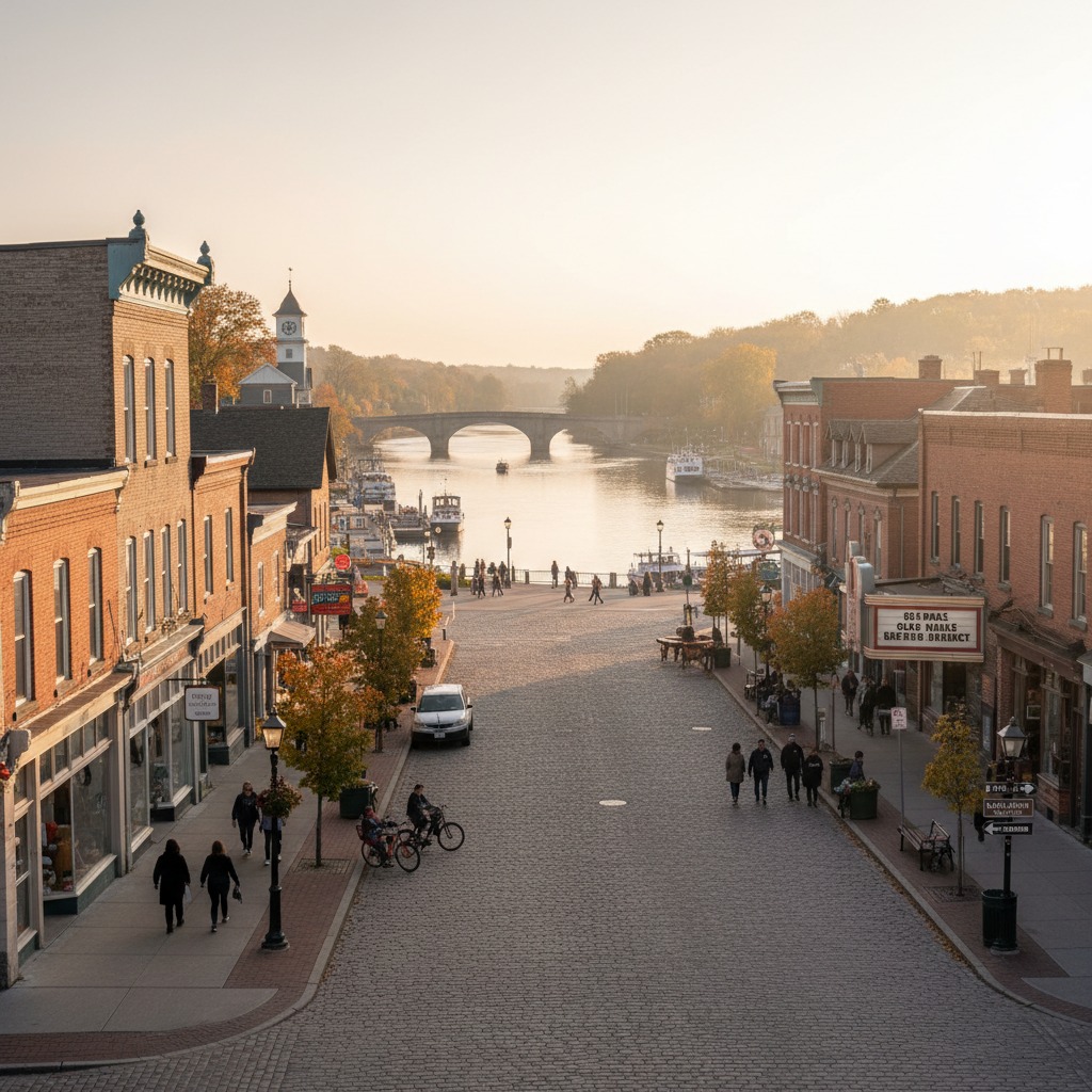
The mill town heritage also explains why many river towns have their commercial centres close to the water. The mill needed to be at the river, and the businesses that served the mill and its workers clustered nearby. This created a pattern where the main street and the river are in close proximity, sometimes parallel, sometimes converging at a bridge. The result is a downtown that feels connected to the water in a way that many lakefront towns do not.
The Valley Effect
Rivers create valleys, and valleys shape communities. A river town sits in a contained landscape, with the valley walls rising on either side and the river at the bottom. This containment produces a sense of enclosure and intimacy that is fundamentally different from the open, expansive feeling of a lakefront. You can see across a river. You know the other bank. The scale is human in a way that a Great Lake shoreline is not.
The valley also constrains growth. A lake town can spread along the shore in both directions, adding new subdivisions on flat land adjacent to the water. A river town is hemmed in by topography. Growth means building up the valley walls, filling in the floodplain, or extending along the river in narrow strips. This constraint tends to produce denser, more walkable communities with a stronger sense of centre. It also produces conflict, because the most desirable land near the river is limited, and the competition between residential, commercial, recreational, and natural uses is intense in a way that it may not be in a lakefront community with more room to spread.
The valley creates microclimates as well. River valleys tend to be warmer in winter and cooler in summer than the surrounding uplands. Fog collects along rivers on autumn mornings. Spring comes to the valley floor before it reaches the surrounding hills. These differences contribute to the distinctive feel of river towns.

The Bridge as Gathering Point
Every river town has at least one bridge, and the bridge is almost always a focal point of the community. Bridges are where you cross the river, but they are also where you stop to look at it. They are vantage points, meeting places, and landmarks. The view from the bridge in Paris, Ontario, looking down the Grand River with the stone buildings on either bank, is one of the most photographed scenes in the province. The bridge at Fenelon Falls frames the cascade that gives the town its name. In Ottawa River towns, bridges connect not just two banks but two provinces, two languages, and two cultures.
The bridge also determines traffic patterns and economic geography. Businesses cluster near the bridge because that is where people pass. The approach roads to the bridge become main streets. In towns with only one bridge, the crossing creates a natural bottleneck that concentrates activity. In towns with multiple bridges, the distribution of crossings shapes the distribution of commercial and residential areas.
Living with Flow
The defining characteristic of a river, the thing that makes it different from a lake or a canal, is that it flows. The water moves. It carries things: sediment, nutrients, leaves in autumn, ice in winter, and occasionally too much water in spring. Living beside a river means living with this movement, adapting to it, and sometimes being threatened by it.
Spring flooding is the most dramatic expression of the river's power. Every river town has flood stories, and the relationship between the community and its floods is one of the defining elements of its character. Some towns have invested heavily in flood protection infrastructure, building berms, walls, and diversions that hold the water back. Others have accepted flooding as a periodic reality and built their resilience around response rather than prevention. A few have engaged in the difficult process of moving development away from the most vulnerable areas, acknowledging that the floodplain belongs to the river.
But the flow is not only a threat. It is also a source of beauty, recreation, and ecological richness. Rivers support different fisheries than lakes, attract different birds, and create different habitats along their banks. The riparian zone along a river is one of the most biologically productive environments in any landscape, and river towns that protect and celebrate these natural areas benefit from the wildlife, the scenery, and the environmental services they provide.
River Towns vs. Lake Towns
The differences between river towns and lake towns are not absolute. There are lake communities with the intimacy of a river valley, and there are river communities as sprawling as any lakefront suburb. But the tendencies are real. River towns tend to be more compact, more vertically oriented, more connected to the water's movement and seasonal rhythms. Lake towns tend to be more horizontal, more spread out, more oriented toward views and horizons.
River towns also tend to have a stronger sense of upstream and downstream. The community is aware that what happens upriver affects them, and that what they do affects communities downriver. This awareness creates a different relationship with the watershed than you find in a lake town, where the water is shared equally on all sides. Ontario's conservation authorities, which manage watersheds rather than political boundaries, reflect this linear reality in their governance structure.

Preserving What Makes Them Different
The character of Ontario's river towns is under pressure. Generic suburban development, the loss of local commercial businesses, and the decline of the industries that originally built these communities all threaten to erode the distinctiveness that makes them worth caring about. When a mill building is demolished for a parking lot, or a riverside park is sold for condominiums, something is lost that cannot easily be replaced.
The river towns that maintain their character are those that recognize what they have and make deliberate choices to protect it. Heritage designation for significant buildings, public investment in waterfront trails and parks, zoning that keeps development in scale with the community, and support for local businesses that give the main street its personality are all tools that work. The river gave these towns their start, their shape, and their identity. The ones that maintain their connection to the water and build their future around it will be the ones that endure as places worth living in and worth visiting.
By James Whitfield, Planning and Development Reporter