Building Near Water in Ontario: A Regulatory Guide
Four levels of government, dozens of rules, and the permits you need before the first shovel hits the ground
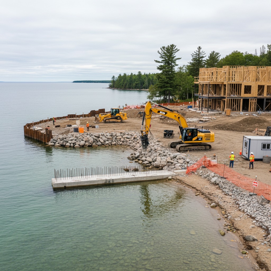
You own waterfront property and you want to build. Maybe it is a new home, an addition, a garage, a retaining wall, or even a simple garden shed. On a suburban lot, you would pull a building permit from the municipality and get started within a few weeks. On a waterfront lot, you are entering a regulatory landscape that involves the municipality, the local conservation authority, possibly the provincial Ministry of Natural Resources and Forestry, and potentially both the federal Department of Fisheries and Oceans and Transport Canada. Each agency has its own application process, its own review timeline, and its own authority to say no.
This is not a complaint about overregulation. There are legitimate and important reasons to control development near water. Flood safety, erosion prevention, water quality protection, fish habitat preservation, and the public interest in navigable waterways all justify careful oversight. But the overlapping jurisdictions create a process that can confuse and frustrate even experienced builders and developers. Understanding who regulates what, what each agency requires, and in what order to approach them can save months of delay and thousands of dollars in wasted professional fees.
The Conservation Authority: Your First Stop
For most waterfront construction projects in Ontario, the local conservation authority is the first and most important regulatory body you will encounter. Ontario's 36 conservation authorities regulate development within their jurisdictions under the Conservation Authorities Act. Their regulated areas typically include all land within a specified distance of a waterbody, all floodplains, all wetlands, and land along the Great Lakes shoreline. In practical terms, if your property touches water, it almost certainly falls within a conservation authority's regulated area.
A development permit from the conservation authority is required for construction, site grading, filling, and changes to waterways within the regulated area. The application typically requires a site plan drawn to scale showing the proposed work in relation to the water, property lines, and existing structures. Depending on the project, you may also need a grading plan, a stormwater management plan, an environmental impact study, or a geotechnical assessment of slope stability. For properties on bluffs or steep terrain, the geotechnical requirement alone can cost $3,000 to $8,000.
The conservation authority's review focuses on natural hazards and natural features. They want to ensure that construction will not be at risk from flooding or erosion, will not increase risk to adjacent properties, and will not harm fish habitat, wetlands, or significant woodlands. They may require setbacks from the water, vegetation buffers, and timing restrictions limiting work to specific months.
Processing times vary widely. Simple applications may be processed in four to six weeks. Complex applications involving new construction near the water or work within flood hazard areas can take three to six months or longer. Pre-consultation before submitting a formal application is strongly recommended and is offered by most authorities at no charge.

Municipal Building Permits and Zoning
The municipal building permit is the authorization most people think of first, but for waterfront construction it is often one of the last approvals obtained. Many municipalities require evidence of conservation authority approval before they will issue the building permit. The building permit itself ensures compliance with the Ontario Building Code, covering structural requirements, fire safety, energy efficiency, plumbing, electrical, and accessibility standards.
Before applying for a building permit, you must confirm that the proposed construction complies with the municipal zoning bylaw. Zoning governs the permitted use of the property, setbacks from property lines and from the water's edge, maximum lot coverage, building height, and numerous other parameters. Waterfront zoning is often more restrictive than zoning for comparable inland properties, with larger setbacks, lower lot coverage limits, and additional provisions related to shoreline protection and vegetation retention.
If the proposed construction does not comply with the zoning bylaw, you will need either a minor variance or a zoning bylaw amendment. A minor variance is appropriate for small deviations from the bylaw, such as a setback that is one metre less than required. It is granted by the local Committee of Adjustment after a hearing where neighbours can object. A zoning bylaw amendment is a more substantial process required for significant departures from the existing zoning, involving a formal application, public meetings, and a council decision. Either process adds months to the timeline and carries the risk of refusal. The zoning rules for lakefront property are worth investigating thoroughly before you begin planning a project.
Federal Requirements: Fisheries and Navigation
Federal regulations come into play when the construction involves work that could affect fish habitat or navigable waters. The Fisheries Act, administered by the Department of Fisheries and Oceans, prohibits the harmful alteration, disruption, or destruction of fish habitat. Any in-water work, including dock construction, shoreline armouring, or work that affects the shoreline within areas that support fish, may require a review and potentially a formal authorization under the Act.
The Canadian Navigable Waters Act, administered by Transport Canada, applies to works constructed or placed in, on, over, under, through, or across any navigable water. If your project involves a structure in or over the water, such as a dock, a boathouse, or a bridge, a review under this Act may be required. The determination of whether a waterway is navigable depends on the specific characteristics of the waterbody, not solely on its size. Even relatively small rivers and creeks can be classified as navigable if they are capable of being used for transportation by watercraft.
Understanding the federal requirements is particularly important for anyone considering construction that affects fish habitat. Violations of the Fisheries Act carry significant penalties, and the obligation to avoid harming fish habitat applies whether or not you were aware of the requirement.
Provincial Requirements and Policy Framework
The provincial government influences waterfront construction primarily through the Provincial Policy Statement, which guides municipal planning decisions across Ontario. Municipal official plans and zoning bylaws must be consistent with the PPS, so its requirements on natural hazards, natural heritage, and water quality flow down to the local level even if you never interact with the province directly.
The Ministry of Natural Resources and Forestry may require permits for work affecting species at risk under the Endangered Species Act, even if the species has not been observed on the property. If the property borders Crown land, which includes the beds of many Ontario lakes and rivers below the ordinary high water mark, additional approvals may be needed for any structure that extends into the water, requiring a Crown land work permit or lease.
Septic System Approvals
For waterfront properties not connected to municipal sewer, a septic system approval is a separate requirement that must be obtained before a building permit is issued. New systems must meet specific setback requirements from the waterbody and water table, verified through a percolation test and soil evaluation. If you are adding bedrooms or plumbing fixtures, the existing septic system may need upgrading. Septic issues are one of the most common obstacles to waterfront construction, particularly on smaller lots where setback requirements limit the available area.

Navigating the Process Successfully
The recommended approach is to begin with pre-consultation meetings with both the conservation authority and the municipality before investing heavily in detailed architectural plans. Many conservation authorities offer screening services that can identify potential regulatory issues based on a preliminary site plan and a description of the proposed work. This early consultation can reveal deal-breaking constraints before you spend thousands on professional drawings.
Hiring a planner or permit agent who specializes in waterfront development is often worthwhile. Their fees, typically $2,000 to $10,000 depending on complexity, are usually recovered through faster processing and fewer rounds of revision.
Budget for both time and money. A straightforward waterfront construction project that would take three months to permit on an inland lot may take six to twelve months on a waterfront lot. Permit fees, application fees, and the cost of required studies can add $10,000 to $50,000 to the project budget depending on complexity. A full environmental assessment for a large project can cost $15,000 to $30,000 on its own.
The regulatory system is imperfect and sometimes frustrating, but it exists because unregulated development near water caused serious environmental and safety problems that are expensive and sometimes impossible to fix. Working within the system, with professional help and realistic expectations about timelines, is the path to a successful waterfront construction project. The Conservation Ontario website provides links to all 36 conservation authorities and their permitting processes, and the Ontario Building Code resources cover the provincial requirements for construction standards.
By James Whitfield, Development Reporter